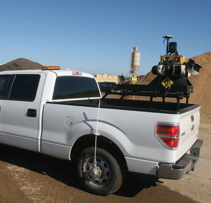
On a recent Arkansas highway reconstruction project, APAC Tennessee was faced with one of the more challenging deadlines for completion in its lengthy history. The company needed to choose between bringing survey crews in from other projects or finding an alternative method to tackle its initial survey needs. It opted to use mobile LiDAR scanning—a method it had been considering for some time—on the entire 8.5-mile project, giving them the data needed to meet their survey demands.
INCENTIVE TO CHANGE
According to Jim Smith, APAC engineering manager, the project not only had some unique demands attached to it, it was also laden with both incentives and penalties.
“This job is challenging in so many ways,” he says. “First, there is a $100,000 per day ‘disincentive’ for not meeting the project deadline, as well as a $100,000 per day incentive for getting done early. There were also some interesting twists to the profile segment of the survey which almost dictated how we tackled the job. We knew that the logistics of getting things surveyed, getting the information in here, getting things moving, and so on, were going to be tough; there simply wasn’t any room for a delay in any part of the process.”
Smith says they’ve done scores of jobs which were survey-intensive before. But he knew that, on this one, dedicating the amount of manpower needed to keep the survey function on track would adversely affect other jobs within the division—not an option they liked.
“When we considered what was needed to get the initial layout, the intermediate surfaces measured and so on, we just felt like we had to look past conventional surveying,” he says. “Just this past year, we had switched to stringless paving and added machine control to many of our graders and pavers, so we were aware that laser scanning was an option available to us. Initially, we were thinking more about static scanning than mobile LiDAR, but we’d heard a good deal about the potential uses for mobile LiDAR. So we contacted Earl Dudley & Associates, the Topcon scanner specialist for this area, and had them show us just how Topcon’s IP-S2 Mobile Mapping System could work for us.”
PROOF IS IN THE PILES
To test the feasibility of scanning in their operation, Smith and his colleague, Jerrad Burns, had Dudley’s crew visit them at APAC’s Memphis location which is one of the company’s larger aggregate storage sites. Because inventorying stockpiles (both by-project and quarterly) is a regular function of the company’s survey crews, it was decided that using the IP-S2 to scan the existing piles would be ideal to see its capabilities.
“This was important for us for a number of reasons,” says Burns. “First, stockpile inventory is a fairly labor-intensive process, which means we have to pull surveyors off other projects to do it. If we could scan the piles and quickly gather accurate inventory, we’d be ahead of the curve in terms of both efficiency and safety. Second, with the road job looming larger, we knew we wouldn’t be able to afford pulling crews from that job to do inventory. This was a huge test for the technology and it immediately impressed us. One 40-minute driving session around the piles yielded more data than what a crew of three or four working a day and a half could compile. We knew we were on the right track.”
He adds that, not only was the time savings impressive, when the IP-S2’s scan results were compared to those done using traditional survey techniques, a slight—but still significant—disparity showed.
“I went out and, using a total station, shot 80 to 90 points. After I did my volumes, I saw that the LiDAR figures were about 2 percent lower than mine, the result of my conventional survey shots having bigger voids than those of the IP-S2,” says Burns. “While 1 or 2 percent might not seem like much, when you consider we regularly inventory over a million tons of material each quarter—and pay an inventory tax on—those savings can be impressive.”
PROFILES IN QUALITY
Burns says their initial thought process had them using LiDAR just for originals and finals on the road project. But, after seeing the degree of speed and accuracy on the stockpile scans, they began to consider the feasibility of doing profiles.
“The Dudley crew instructed us on how to place survey control reflective targets for the LiDAR and came out and helped us start scanning the original profiles,” says Smith.
Because the road being reconstructed originally consisted of 9 inches of asphalt, placed over an existing concrete roadway, APAC was thrown a bit of a curve by AHTD’s engineers.
“They said the specification required that we profile the concrete below, not the existing asphalt,” says Smith. “So we needed to mill off 8 miles of asphalt and gather profiles of that concrete below. It became apparent that the IP-S2 was going to have something of a baptism by fire. We broke the job up into five segments and as soon as one segment was milled and cleaned up, we would establish control and set down targets every 1,000 feet, with millimeter points every 400 feet for verification, and run the LiDAR. Doing it in this way, we got the full 8 miles milled off in 10 days. As to the data collection, we figured it would have taken two full crews somewhere between 2 to 3 weeks to gather 8 miles of data. By comparison, one person did the full eastbound and westbound sections in a total of 4 hours. This made all the difference for us.” ■
About the Author Larry Trojak is president of Trojak Communications, a Minnesota-based marketing communications firm. He has written for the construction, recycling, demolition, scap, and aggregate processing industries.
Modern Contractor Solutions, August 2014
Did you enjoy this article?
Subscribe to the FREE Digital Edition of Modern Contractor Solutions Magazine!


