
Earthwork estimating has always required a balance of speed, accuracy, and judgment. Contractors are often asked to bid on complex sitework projects under tight deadlines, with incomplete information, changing drawings, and significant financial risk. Because most excavation work is bid on a lump-sum basis, quantity accuracy is critical. An overlooked item or incorrect calculation can have a direct impact on profitability.
For decades, earthwork software has helped contractors improve that process. The industry moved from paper plans and digitizers to PDF takeoff, CAD import, 3D surfaces, GPS model exports, and more connected estimating workflows. Each generation of software made the estimator faster and gave contractors better tools to measure, validate, and communicate the work.
New technology shifts in A.I. and solid modeling mean the future of earthwork software is not simply about drawing lines faster or producing longer reports. The next generation of tools will help estimators understand the job more completely, identify risk earlier, validate the model more visually, and connect estimating data to the field with fewer gaps.
A.I. AS A SECOND SET OF EYES, NOT A REPLACEMENT
Artificial intelligence is receiving considerable attention across the construction industry, but its value in earthwork depends on how it is applied. Estimating is not a task that should be handed over blindly to an algorithm. Experienced estimators understand construction intent, plan quality, phasing, site conditions, production risk, and company-specific bidding strategy. Those decisions require human judgment.
That is why the most practical use of A.I. in earthwork software is not a replacement. It is assistance. A.I. can help reduce repetitive work, review large amounts of job data, and flag inconsistencies, missing information, unusual quantities, or areas that may need closer attention. Contractors do not need a black box that produces unexplained quantities. They need intelligent tools that help their people work faster while keeping the estimator in control of the final decision.
That philosophy is central to how InSite Elevation Pro is approaching artificial inteligence. A.I.-based job reviews, A.I.-assisted data entry, and future automated workflow enhancements are being developed to help users find issues faster and reduce manual effort without removing their oversight. The estimator remains responsible for the job; the software simply helps them see more, check more, and work more efficiently.
SOLID MODELING FOR MORE ACCURACY AND FASTER CALCULATIONS
For contractors bidding lump-sum earthwork, confidence matters. More accurate quantities help reduce risk, improve bid reliability, and create a stronger connection between takeoff, 3D review, GPS modeling, and field execution.
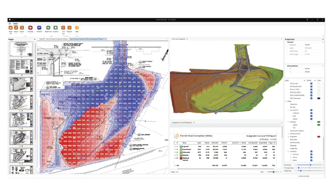
By moving from grid-based calculation to solid modeling, Elevation Pro is advancing from sampled estimates to true 3D surface-based earthwork calculation. Traditional systems use grids or cross-sections to divide the site into samples and estimate quantities from them. Solid modeling calculates the volume between actual 3D surfaces and project boundaries, producing more precise, faster, and more defensible cut-and-fill quantities.
This is especially important on modern grading projects, where ponds, pads, ditches, slopes, subgrades, stripping areas, and complex site transitions can change quickly across short distances. Solid modeling better captures those changes, reduces dependency on sampling, and gives estimators greater confidence that the quantities reflect the true shape of the job
BRINGING CLARITY TO UTILITY TAKEOFF
Utility takeoff is one of the highest-risk parts of sitework estimating because underground conditions are constantly changing. Pipe depths, trench widths, OSHA requirements, bedding, cover, backfill, and soil strata can all affect the true cost of the work.
Traditional methods often rely on average depths and standard trench assumptions, which can hide costly conditions. Elevation Pro’s TrenchVision 3D utility module uses solid modeling to represent trenches, excavation, and backfill as true 3D objects.
By modeling centerlines, structures, inverts, bedding, cover, backfill, and changing depths, TrenchVision 3D gives estimators a clearer view of underground work before bidding. The result is more accurate utility quantities, better risk visibility, and greater confidence in the numbers.
FROM MEASUREMENT TO UNDERSTANDING
The broader trend is clear: Earthwork software is moving from measurement to understanding. The best systems are no longer just digital measuring tools; they are becoming integrated environments where estimators can import multiple data sources, align plan sheets, build surfaces, model underground work, validate in 3D, use A.I.-assisted review, and support GPS workflows.
That does not reduce the importance of the estimator. It increases it. As software becomes more capable, the estimator’s expertise becomes even more valuable, because better tools allow that expertise to be applied more completely and consistently.
Elevation Pro’s new A.I. functionality, solid modeling capabilities, and TrenchVision 3D utility module reflect this next stage in the industry—intelligent, visual tools built around how sitework is actually estimated and constructed. The goal is not technology for its own sake. The goal is better quantities, clearer communication, stronger validation, and greater confidence in every bid.
about the author
Steve Warfle is the CEO of InSite Software, a software company providing utility and takeoff solutions for grading contractors, civil estimators, and preconstruction teams. For more, visit www.insitesoftware.com.