

The cornerstone of a successful bid lies in the takeoff process. By harnessing the power of GPS-enabled smartphones and tablets, takeoff estimators can achieve unprecedented levels of accuracy and efficiency.
Modern 3D software solutions that can simultaneously combine data from multiple sources help minimize risk by identifying challenges from pre-construction through each phase of construction. Communicating this information clearly with all stakeholders—including developers, engineers, general contractors, and subcontractors—ensures projects remain on schedule and within budget.
Identify existing challenges. To minimize construction delays caused by change orders, ensure existing conditions and demolition plans are verified using topography data collected from drones or data collectors, along with imagery from Google Earth. The ability to combine these multiple sources and provide a clear presentation of any unforeseen omissions or inaccuracies both graphically and with quantities is critical on lump-sum projects.
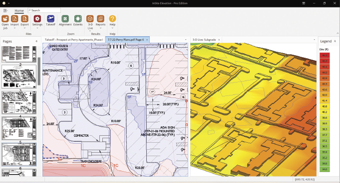
Takeoff mimics construction. A full takeoff should provide numbers and graphics for the entire grading process. Documentation in easily sharable formats that include the approved site plans overlayed with accurate demolition, stripping, and cut-and-fill depths and identifiable quantities helps plan the process step by step.
While each site is different, itemized quantities for topsoil stripping, demolition, cut and fill, and material takeoff for paving, sidewalks, topsoil respread, etc., are the minimum requirements. In some sites, soil borings must be entered to quantify the cut by strata and identify unsuitable material which may need to be hauled off site or used in non-structural regions. Sites with layback (vaults, retaining walls, deep foundations, etc.) that require a phased approach must be easily quantified for each phase and clearly marked.
A detailed report with fill requirements by region identifies the structural fill requirement necessary for load-bearing areas like paving and buildings and the non-structural areas where lower quality fill may be re-used.
Communicate with your team(s). From the earliest idea for development to the completed project, the need to share information is crucial. Systems that can communicate data in the recipient’s preferred format can ease communication. For example, a DWG file is best for engineering firms whose language is CAD, while the original PDF plan documents overlaid with supplemental data like cut-and-fill depth contours provides an easy method of communication to GCs and site staff.
Location based data on mobile devices. Smartphones and tablets running Google Earth and other geo-browsers support KMZ files. When aligned to the site, the current location is shown on the display. While the GPS in a phone doesn’t provide the accuracy necessary for grade staking, the GPS coordinates are very suitable for:
Reconnaissance. A site plan, utility plan, etc., aligned to the site communicates close locations of all site features and is accessible to anyone with a phone or tablet for location-based information. With location-based data, even a ribbon cutting can be more impactful when attendees know where the driveway and building corners are.
Delivery location. Marking up a site plan with delivery locations and then sending a KMZ file to the delivery vendors for utility structures, pipe, aggregate, and site trailers, etc., eliminate inconvenient placement and time spent on relocation.
Cut and fill. Contours showing precise depths of cut-and-fill overlaid on any site document provide the scope of work with definable intervals and allow easy determination of the general cut or fill depth at a specific location.
Planning. With today’s reality of jobsites often being short staffed, the order of the grading process can be provided with step-by-step instructions. For example, a KMZ that identifies the stripping and demolition areas and the stockpile locations clearly marked can keep production moving.
Successful bidding hinges on precise takeoff processes enhanced by GPS-enabled smartphones and tablets, ensuring estimators achieve improved accuracy and efficiency. Advanced 3D software further reduces risk by integrating diverse data sources, identifying challenges across all construction phases from pre-construction onward.
for more information
Insite Software offers solutions for earthwork takeoff and GPS machine control modeling. For more, visit www.insitesoftware.com.